STAR set out to sample several major storm events that passed over southern Baffin Island or affected its coastline and was successful at doing so. One such event was the passage of the remnants of hurricane Noel that affected eastern Canada and Davis Strait. The use of a research aircraft allowed STAR researchers to fly directly into storms to gather extensive information about storm structure and terrain effects in combination with the multitude of ground-based observations. As a result, detailed documentation of precipitation, cloud, wind and temperature characteristic associated with weather systems in the eastern Arctic was collected for the first time. Features such as terrain-induced precipitation was studied with great detail, comparing aircraft measurements with CloudSat retrievals, ground-based radar, and model simulations, which tend to reproduce these events well in most cases.
Strong winds, which are common on Baffin Island, as also due to storm interactions with the local terrain, In Iqaluit, these events occur mainly from the northwest as air is funneled down the Sylvia Grinnell Valley. It is also known that extremely hazardous northeasterly events can occur due to mountain wave/downslope wind processes. Accurately predicting when the extreme north-east winds will occur and how strong the winds will become is difficult due to a lack of data in the region combined with complex processes that create these events. Unfortunately, no extreme north-east wind events occurred during STAR. However, analysis of historical events via available observations and high-resolution modeling have shown that high resolution (2.5 km) weather models can replicate the critical processes that control these events, although they still tend to underestimate the maximum wind speeds and when the events begin/end. Processes responsible for these events are similar to mid-latitudes, although Arctic events can be more extreme due to stronger lower atmosphere stability. Thus, new insights from future mid-latitude or Arctic research will improve Arctic event prediction capabilities.
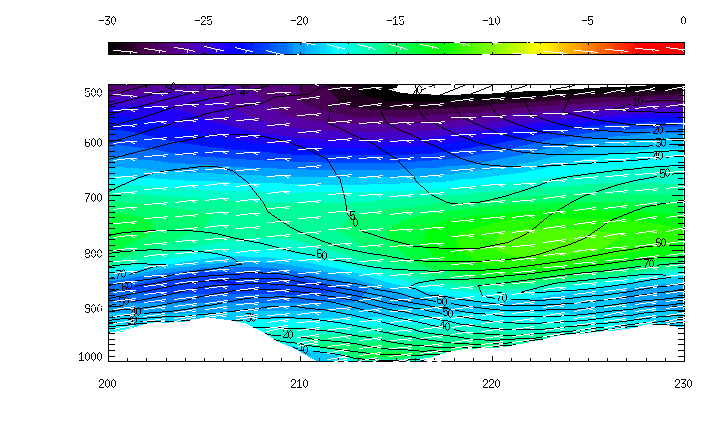
GEM—LAM west to east cross-section of Frobisher Bay for the February 2007 strong north east wind event at Iqaluit, Nu. The vertical axis represents height in the form of pressure in mb. Temperature in degrees Celcius is indicated by the shading and referenced by the colour bar above the plot. Winds in excess of 120 km/h were reported at the Iqaluit Airport (CFYB). The model results show that the processes controlling this type of event are resolved by the model. However, more often than not, the model tends to underestimate the maximum wind speed at Iqaluit. Sensitivity studies are underway to determine the thresholds for these processes in the model.