STAR was geographically focused on the southern Baffin Island region of Nunavut, Canada. The area around Frobisher Bay on Southern Baffin Island is dominated by two mountain ranges (Figure 1). The Meta Incognita Peninsula, to the west-southwest, is characterized by low mountain ranges with a typical elevation of 600 m, and peaks to about 750 m within 50 km of Iqaluit. On Hall Peninsula, to the north and north-west of Iqaluit, the mountains are generally higher, reaching about 1,000 m within 100 km of the city, with a maximum elevation of 1,295 m close to the southwest coast of Cumberland Sound. These mountains have a strong impact on the surface weather near coastal communities such as Iqaluit. The highest topography on southern Baffin Island is in excess of 2000 m and associated with the Penny Ice Cap on the Cumberland Peninsula north of Pangnirtung. Available operational meteorological data on Southern Baffin Island are hourly surface observations at the locations shown in Figure 1, and twelve-hourly soundings at Iqaluit. Iqaluit is located at 63?45’N, 68?33’W.
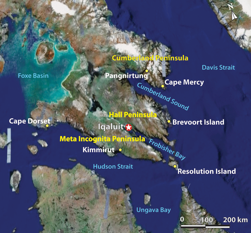
Figure 1: Geography of the STAR project area as well as standard Environment Canada hourly surface weather reporting stations (in white text).
Arctic storms and severe weather were sampled using standard meteorological field measurements and remotely sensed observations. Field measurements were collected during two field campaigns in fall 2007 (October 10 – November 30) and in winter 2008 (February 1 – February 29). The base for the surface observations was the Environment Canada Office in Iqaluit. Meteorological instruments were installed in the last week of September and remained operational throughout the fall field campaign. Certain instrumentation remained in the field for both the fall storm project and the winter blowing snow project.
The National Research Council of Canada’s (NRC) Convair-580 research aircraft was instrumented by Environment Canada and NRC to collect internal storm measurements of cloud microphysics, thermodynamics, wind and the 4-D dynamic and precipitation structures of storms within a 500 km radius of Iqaluit from November 5 - 30, 2007 (Figure 2). The aircraft enabled STAR scientists to probe storm events as they approached the area, during their passage and departure over the study area.
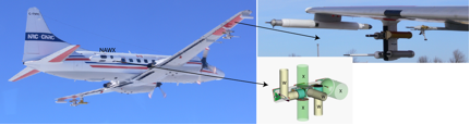
Figure 2: Convair-580 research aircraft instrumented by the National Research Council (NRC) and Environment Canada. The schematic and inset picture shows the configuration of the polarized Doppler X and W band (NAWX) radars and some of the cloud microphysics probes, respectively.
A portable X-band Doppler radar was deployed at the Environment Canada Office in Iqaluit (October 10 - November 30, 2007). No operational radars exist in northern Canada. This instrument was used in real-time to map precipitation and wind fields within a radius of approximately 50 km of Iqaluit. It was also used to validate satellite (CloudSat, AMSR, ASTER, MERIS, and MODIS) and surface based precipitation measurements.
A passive microwave radiometer (Radiometrics WVR-1100) provided time-series measurements of column-integrated water vapor and liquid water content over Iqaluit. The STAR radiometer operated looking upward at a sampling resolution of about 1-minute. These data are available only during the fall field campaign, October 10 – November 30, 2007.
An acoustic Doppler sodar system (Remtech PA1-NT) was also used at Iqaluit to assess the three component winds between 0 – 1.2 km AGL with a 30 m vertical resolution every 30 minutes. This instrument has provided an assessment of the local microclimate and high resolution wind data that has been used for low level jet analysis. Similar to the other remote sensing instruments, it was operational October 10 – November 30, 2007.
A small mesonet of 10 automatic weather stations, within a 100 km radius of Iqaluit was installed at the end of September (Figure 3). Nine of these stations measured 3m wind velocity, pressure, 2m temperature, and 2m humidity every 10-minutes. The weather stations were positioned over various forms of topography to assess storm influences on surface weather. By collaborating with the local northern groups, Indian and Northern Affairs Canada (INAC) and Qulliq Energy Corp., four of the mesonet weather stations (indicated in red on Figure 3) provided near real-time weather data (i.e. recent historical data available once a day).
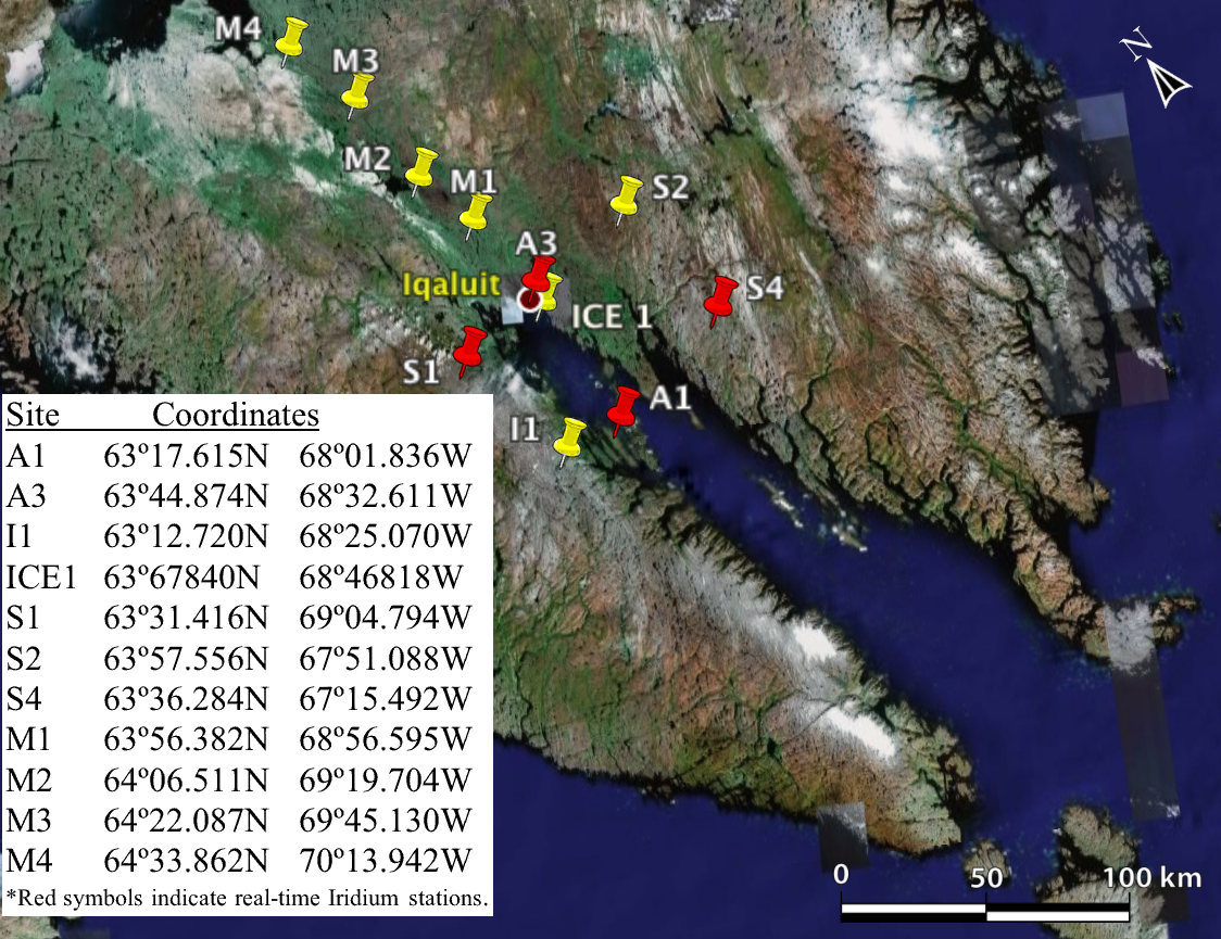
Figure 3: STAR mesonet of surface weather stations. Red markers indicate stations with real-time data access via Iridium satellite phone.