
Today, the interior of southern Baffin Island lies at roughly 100 to 400 meters above sea level. However, rocks lying on the surface and exposed along river beds throughout the interior bear the remains of an ancient ocean floor.
Oceans are home to tiny creatures, including diatoms, radiolarians, and sponges, that have skeletons made of silica. When these creatures die, their skeletons settle to the ocean floor, forming a silica ooze. Over time, this ooze becomes buried and solidifies to form a type of sedimentary rock called chert.

Photomicrograph of ten species of radiolaria. Photograph by Randolph Femmer is public domain from USGS Library of Images From Life.
When we look at chert through the microscope, we can see that it’s made up of lots of tiny grains of quartz (or microcrystalline quartz), with other minerals in between. These other minerals may be contaminants present when the chert first formed, or may have formed later as a result of the environment in which the chert formed. Sometimes, chert may even contain fossils of ancient sea creatures visible under a microscope, or even to the naked eye.

Photomigrograph of a chert sample from LbDt-1. The body of the rock is microcrystalline quartz with other micromineral inclusions. Note the fossil inclusions. The honeycomb-like fossil near the centre top of the image is a fossil sponge.
Chert is as variable as the ocean environments in which it is formed. It can be colourful, or it can be a relatively subdued, monotone shade of brown or grey. Sometimes it contains lots of minerals and fossils, and sometimes it is relatively pure microcrystalline quartz. One thing that seems common to chert almost everywhere is that, when stone tool-using people ran across it, they picked it up and made it into things.

Polished chert sample from the Alibates Flint Quarries National Monument in Texas, USA. Note the colour variation within a single sample!

Samples of chert from southern Baffin Island. Note that, while the colours are, in general, more muted than those of the Alibates sample, there is still a lot of variation in each piece!
Though it varies a lot in quality, chert was often the best available raw material for making stone tools. Because it is made up of lots of tiny quartz grains packed in close to each other, the energy that enters a piece of chert when it is struck during toolmaking tends to travel in even, predictable patterns. This means that toolmakers have a certain degree of control over how chert breaks when they hit it, which is vital to producing stone tools with a regular shape and useful, sharp edges. When energy running through a piece of chert hits a large impurity, say a large crystal of quartz, or a small fossil, the path of the energy is disrupted, causing the stone to break in unpredictable, undesirable ways. This is why archaeologists tend to refer to chert with lots of inclusions, or with irregular quartz crystal sizes, as “low-quality”.
On southern Baffin Island, chert isn’t a common naturally-occurring rock in coastal areas. To find chert in amounts large enough to make the tools they needed to hunt, carve, and prepare skins for sewing, the Tuniit (used here to refer to both the Pre-Dorset and Dorset, who were the only people in the area that made chipped tools from chert), had to travel inland. In the limestone formations that surround Netilling, Amadjuak, and Mingo Lakes, chert can be found either just lying on the ground, or at some sites, as nodules inside the limestone, itself. Chert from southern Baffin Island tends to be grey, brown, and sometimes white. It also tends to have a lot of inclusions, and is often very fragmented from repeated freezing and thawing. There is evidence that, despite these challenges, the Tuniit still made good use of this chert. Two recently documented sites show signs that people once traveled there to gather chert, and at one of the sites, begin the first stages of making stone tools.
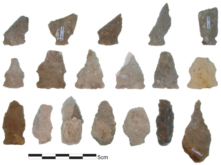
Chert tools from sites on southern Baffin Island.
Two ancient quarry sites: LdDx-2, and LbDt-1

Map of southern Baffin Island showing major bodies of water and approximate location of sites discussed below
During the summer of 2013, a team of archaeologists and geologists from the University of Manitoba documented two chert quarry sites in the interior of southern Baffin Island. The first site that was recorded, LdDx-2, is located on the south shore of Amadjuak Lake, near the outlet of the Mingo River. At this site, chert is part of surface gravels, and can also be found inside limestone boulders weathering away on the surface of the site. We think that these features are the final stages of limestone bedrock weathering in place, rather than the result of glacial deposition.

View of LdDx-2. Note the gravel on the surface, and the boulders lying in the low ground near the centre of the photograph. Both of these features contain chert.

A piece of chert (just above the blade of the trowel) still embedded in a weathering limestone boulder at LdDx-2
Within a few minutes of arriving at LdDx-2, the research team was able to fill several sample bags with chert pieces good enough to be used to make stone tools. There is no reason to think that the Tuniit would have done any differently. Although there are signs of human occupation at LdDx-2 (stone tent rings, etc.), there is very little human-made stone debris present. However, at a nearby Tuniit campsite, LeDx-42, stone flakes produced during tool manufacture are abundant. It is possible that people only stopped at LdDx-2 long enough to pick up enough small, easy to carry pieces of chert to replenish their toolkits, before moving on to longer-term camps where the work of making stone tools began.
The second site recorded in 2013 is called LbDt-1, and is more complex. LbDt-1 is located on the Hone River, about 100km WNW of Iqaluit. At this site, like at LdDx-2, chert is present in gravels and weathering boulders. At LbDt-1, though, chert also occurs in the form of lumps called nodules inside intact limestone bedrock.

Nodules of chert embedded in limestone bedrock at LbDt-1
LbDt-1 is also different from LdDx-2 in that there is a thick layer of human-made (or, anthropogenic) stone debris covering part of the site. Evidently, people not only came to LbDt-1 to gather chert, but also to begin the process of turning the chert into stone tools.

Chert debitage layer covering part of the site surface at LbDt-1
As you can see from the pictures on this page, chert from both LdDx-2 and LbDt-1 varies in colour; it can be grey, brown, or white. Sometimes, one lump of chert can be all three colours! Below are some rotating images of samples from LdDx-2 and LbDt-1 taken with a 3D laser scanner. These should give you an idea of what chert on southern Baffin Island looks like right after it comes out of the ground.

3D scan of chert sample from LdDx-2. The white outer layer on this specimen is called 'cortex'. Cortex forms on exposed surfaces of chert when they are affected by weathering processes over time.

White chert from LdDx-2. The shiny crystals on this sample are macrocrystalline quartz.

Chert sample from LbDt-1

Chert sample from LbDt-1. The black patches on these samples are lichen that grows exposed rock surfaces on the Tundra.

Fossil found at LbDt-1. This specimen measures about 5 inches across.
Our research team was absolutely thrilled to find these two sites. Archaeologists have spent the past two decades trying to figure out where the Tuniit on southern Baffin Island were getting their chert from. Now we’d finally found at least a couple of the sites they went to to get stone! You might be asking yourself why archaeologists are so interested in finding and analyzing stone extraction sites. Fair question! While we tend not to find the small, beautifully made knife blades, harpoon tips, and carving tools that are famous hallmarks of the Tuniit at these sites, the stone flakes people leave behind at sites like LbDt-1, and even the leftover raw materials at these sites, can tell us a lot about the lives of ancient toolmakers.
Stone flakes left over from tool manufacture, called debitage, can tell archaeologists about how past peoples made their stone tools, scheduled stone procurement, and taught toolmaking to their children. Raw material left behind at quarries can be analyzed to detect source-specific chemical signatures – which can then be used to link stone artifacts back to the source they came from. This information (called artifact provenance) can help archaeologists reconstruct group movement and trade routes, and gives us insight into how people decided which stone to make their tools from.
We are currently in the early stages of a provenance study of chert artifacts on southern Baffin Island, that has only been made possible by samples of chert taken from LbDt-1 and LdDx-2. Preliminary analyses have shown us that it may not be possible to completely distinguish between chert from the two sites, however, we have identified some interesting patterns in the chemical data.

Triplot produced through principal component analysis of trace element data from chert samples from LbDt-1 and LdDx-2
There appears to be two chemical signatures represented in the data, with each appearing at both sites. It's possible that chert at the two quarries comes from outcrops of the same two layers, or strata. When we add chemical data from artifacts from two coastal sites near Iqaluit and four inland sites things get really interesting...

Triplot produced through principal component analysis of trace element data from chert samples from LbDt-1 and LdDx-2 and artifacts from coastal and inland site
The artifacts from the inland sources, unsurprisingly resemble material either from LbDt-1 or from both inland quarries. Artifacts from the two coastal sites, however, either look like material from LbDt-1, or look like they've come from quarries that we haven't sampled yet. This is an exciting result for us, because it tells us that there are more sites out there to find!
Now that we can link some archaeological sites to quarries using chemical data, we've started looking at landscapes between these linked sites to figure out how the Tuniit may have traveled between them. So far, we've made a map that combines information about slope, ground cover, and distance to water - all variables we think were important to how the Tuniit chose their pathways. Using special software, we're able to draw the most time and cost-efficient paths across this map. Archaeologists call these Least Cost Pathways
Here's what the least cost pathway running between LbDt-1 and one of the coastal sites (Tungatsivvik, or KkDo-3) looks like:

Least cost pathway between LbDt-1 and Tungatsivvik (KkDo-3)
The next step in our research is to look at chert from other sources in the arctic to see if we can identify chert from southern Baffin Island on a regional, if not a quarry scale. Then, we'll be looking at artifacts from sites along the coast of the Davis and Hudson Straits, to see if we can't link archaeological sites in those regions to quarries in the interior.